Client: Redditch Borough Council/Environment Agency
This major project has been undertaken on behalf of Redditch Borough Council and has recently been completed. The work undertaken has been to produce a comprehensive strategic framework for River Arrow Country Park, in order to guide the future development and maintenance of the Park. The commission included preparing a £2.5M bid to the Heritage Lottery fund, as well as supporting other planned bids to funders such as Sport England and the Football Foundation.
The park follows four miles of the 364ha River Arrow and divides the new town of Redditch in two. As well as being the most important resource for informal recreation in the borough, it contains two Scheduled Ancient Monuments, a local nature reserve, two visitor centres, a museum and extensive sports facilities, including national-standard BMX and Skate Park facilities. The Country Park’s landscape is the most important part of the borough in terms of both historic and natural heritage, telling the story of Redditch from pre-Roman times, through the early industrial revolution to the establishment of the new Town and beyond.
The work has been carried out by a multi-disciplinary team managed by NW Environmental, comprising several of our associates:
Landscape Matters – landscape masterplanning
Moss, Naylor Young – historic heritage
Andy Maw Design – graphic design and visualisations
CSB Architects –designs for visitor centres and sports facilities
Horritt Consulting – hydrologists
Rita Wyatt – visitor surveys
Aspects of the work have included:
- Two workshops bringing together the clients and other stakeholders, resulting in the re-establishment of the Country Park User Group.
- Presentation to Councillors
- Presentations and meetings with a large range of stakeholders including the County Council, Community Forum, Government Agencies and third sector organisations.
- Face to face surveys with 200 local residents and park users.
The Strategic Framework is based around a park-wide masterplan with detailed plans and visualisations for key elements within the overall framework, including provisional costings and extensive supporting evidence. Key elements of the framework include:
- Identifying a single identity across the Country Park, with clearer zoning of activities and better connectivity within the park and into surrounding areas.
- Refurbishment of the main visitor centre and Bordesley Abbey Visitor Centre, with visualisations.
- Improvements to and new football changing rooms and establishment of a wheeled sports hub, with architectural designs.
- Improving the network of paths and trails and enhanced segregation between different user groups (walkers, riders, cyclists).
- Improvements to access by visitors using all relevant modes of travel
- A strategy for improving education and interpretation, including making better use of new technologies.
- Ways of broadening the site’s user base and increasing community engagement and volunteering.
- Refurbishment and improvement of sports facilities across the Country Park
- Detailed solutions to address safety, heritage conservation and fish passage issues at each of six weirs.
- Improving the setting and interpretation of historic assets across the Country Park.
- Nature conservation management proposals, including the creation of new wetlands and meadows.
- Options for new governance arrangements
- Review against Green Flag and Accredited Country Park criteria
- SWOT and Risk Analyses of the park
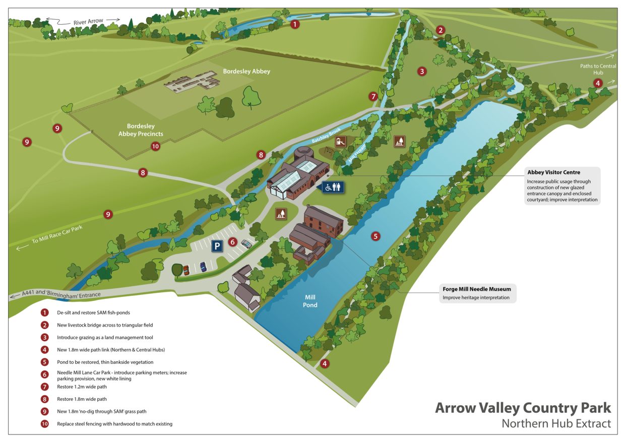
Visualisation for Bordesley Abbey and Forge Mill Scheduled Ancient Monuments, Arrow Valley Country Park realised for us by Andy Maw Design
Cannock Chase to Sutton Park UNESCO Biosphere Reserve Feasibility Study
Client: Natural England
UNESCO Biosphere Reserves are the equivalent of World Heritage Sites for biodiversity, rather than cultural, heritage. Similar levels of heritage importance are required, and similar emphasis is given to using the heritage assets to support sustainable development in the context of local social, economic and environmental issues through alignment with UNESCO’s Sustainable Development Goals.
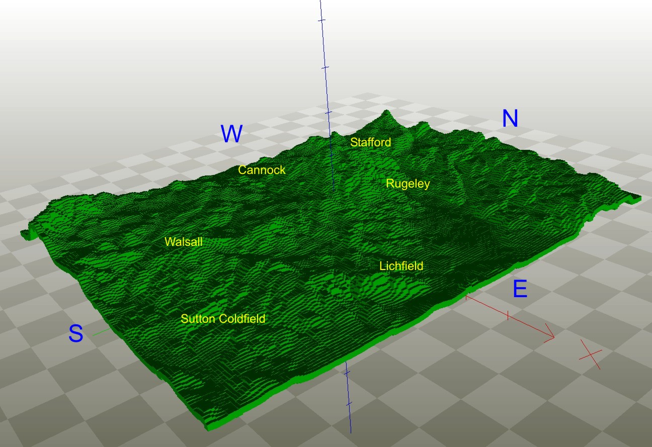
In 2014-2015 following initial work by NWE on the potential for a heathland restoration partnership in Birmingham, Staffordshire and the Black Country, we were commissioned by Natural England to produce a detailed study into the feasibility of establishing a UNESCO Biosphere Reserve linking the Cannock Chase Special Area of Conservation and Sutton Park National Nature Reserve. The work included detailed analysis of the area’s economic, social and environmental character and the synthesis of a detailed masterplan from various existing and aspirational proposals and initiatives.
Forty-two organisations were consulted individually during the production of the report, and over thirty of these participated in a stakeholder workshop held at the Museum of Cannock Chase. As well as several local authorities and Local Economic Partnerships, four government agencies, environmental NGOs and landowner organisations consultees included a Canal Restoration Trust, Local Nature Partnership, Canoe England and Wolverhampton University.
We formally presented the draft findings of the feasibility study to the UK Man and Biosphere Committee (the UK equivalent of ICOMOS-UK for Biosphere Reserves). They were highly supportive of the proposals and their feed back helped contribute to the direction of the final report.
It was also necessary to ensure the study was fully compatible with the more advanced proposals for a Black Country GeoPark, another UNESCO designation.
The final report was 137 pages in length with appendices plus 23 maps produced using GIS which document many of the relevant issues and options for the UNESCO Biosphere Reserve. In effect the document combined three elements -an appraisal of the assets and past initiatives; an options review and assessment against the UNESCO criteria; and an outline business plan demonstrating how the UNESCO Biosphere Reserve would operate in practice.
An eight-page summary document was produced, largely addressing the main issues from the perspective of Local Economic Partnerships. The report has been well received and it is anticipated that the Staffordshire LNP and Birmingham and Black Country LNP will take the concept forward in due course when resources for a major initiative become available.
How do you demonstrate to schools the different properties of hard engineered surfaces, grassland and peatlands?
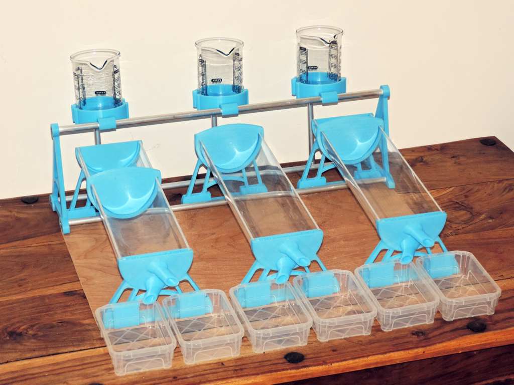
One approach has been to use pop-bottles cut in half and filled with divots of soil, but the Devon Wildlife Trust wanted something more sophisticated and reliable to show the differences in surface runoff and absorbency of different soils.
Our solution is a bespoke soil-hydrology demonstrator, divots of real grassland or peat can be fitted into the transparent troughs - or even a custom-made 'concrete block' can be slid into place. Accurate amounts of water can be poured onto the different 'habitats' and both runoff and groundwater percolating slowly through the body of the soil are collected separately. Qualitative demonstration work fine, but you can also make quantitative measurements to show the differences between runoff, groundwater flow and how much water is absorbed into the soil for each habitat.
"Wow! What a great science experiment" - teacher feedback
Our use of custom-designed 3D printed parts on a wooden baseboard creates a robust and attractive piece of equipment to engage and fascinate pupils of all ages. The whole unit packs up into a relatively small and secure plastic box for transportation and storage. Made of PLA, wood, aluminium alloy and glass it is also recyclable at the end of its life cycle.
The solid hydrology demonstrator is available as single or multiple units made to order, please contact us with your requirements. We are also happy to discuss modifications or other bespoke demonstration units you may require.
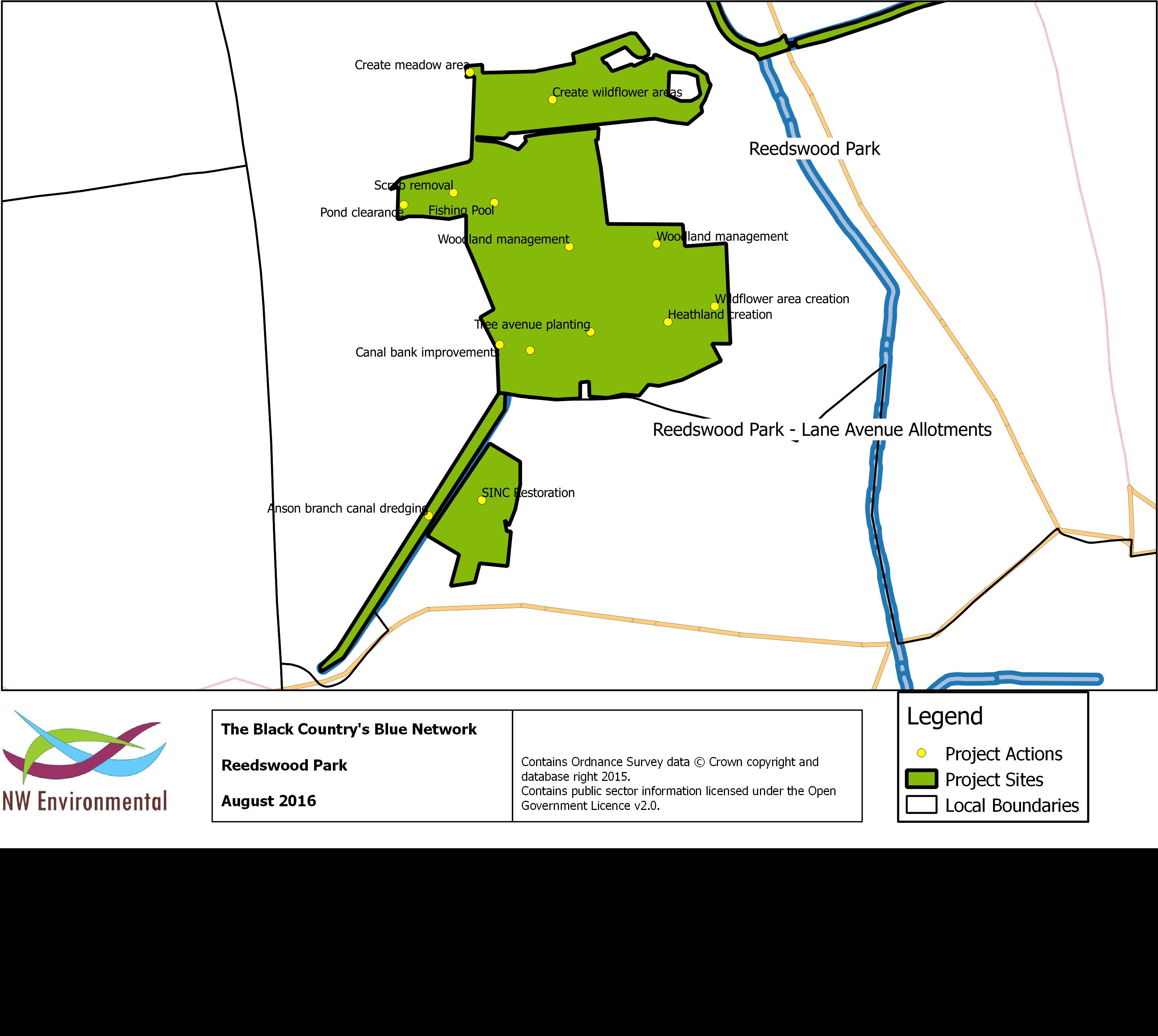
Black Country Blue Network – (Wolverhampton City Council)
NWE worked with partners across the Black Country, including local authorities, voluntary organisations and Government agencies to support Wolverhampton Council (as accountable body) in pulling together a major project to seek resources for European Structural Funding.
Black Country Blue Network will create a high quality ecological network with a diverse range of habitats, centred on the area’s historically important waterways and associated green spaces. This will be achieved through a three-year programme of infrastructure and habitat improvements improve habitats along canals and rivers in the Black Country as well as other key nature greenspaces linked into this blue network facilitating better visitor management and improved access for local communities. The outline bid was for £1.7 million ERDF out of a total project cost of £3.8 million. Following the DCLG’s response to the outline submission we have made further input, including GIS mapping of the projects and production of an evaluation strategy and the project is expecting final approval in the immediate future.
NWE organised two stakeholder workshop events and worked closely with all the partners and the Black Country technical Assistance Team. We were able to identify a strong unifying theme (the canal and river network) and bring together a wider range of projects and maximise the synergies between projects and existing strategic priorities. The project has been quoted as an exemplar by the DCLG who wish to encourage other innovative urban projects.
We were thrilled to work with the Devon Wildlife Trust, and their partners the Dartmoor National Park Authority, the Friends of Dartmoor and the Duchy of Cornwall to create a unique working model of the National Park!
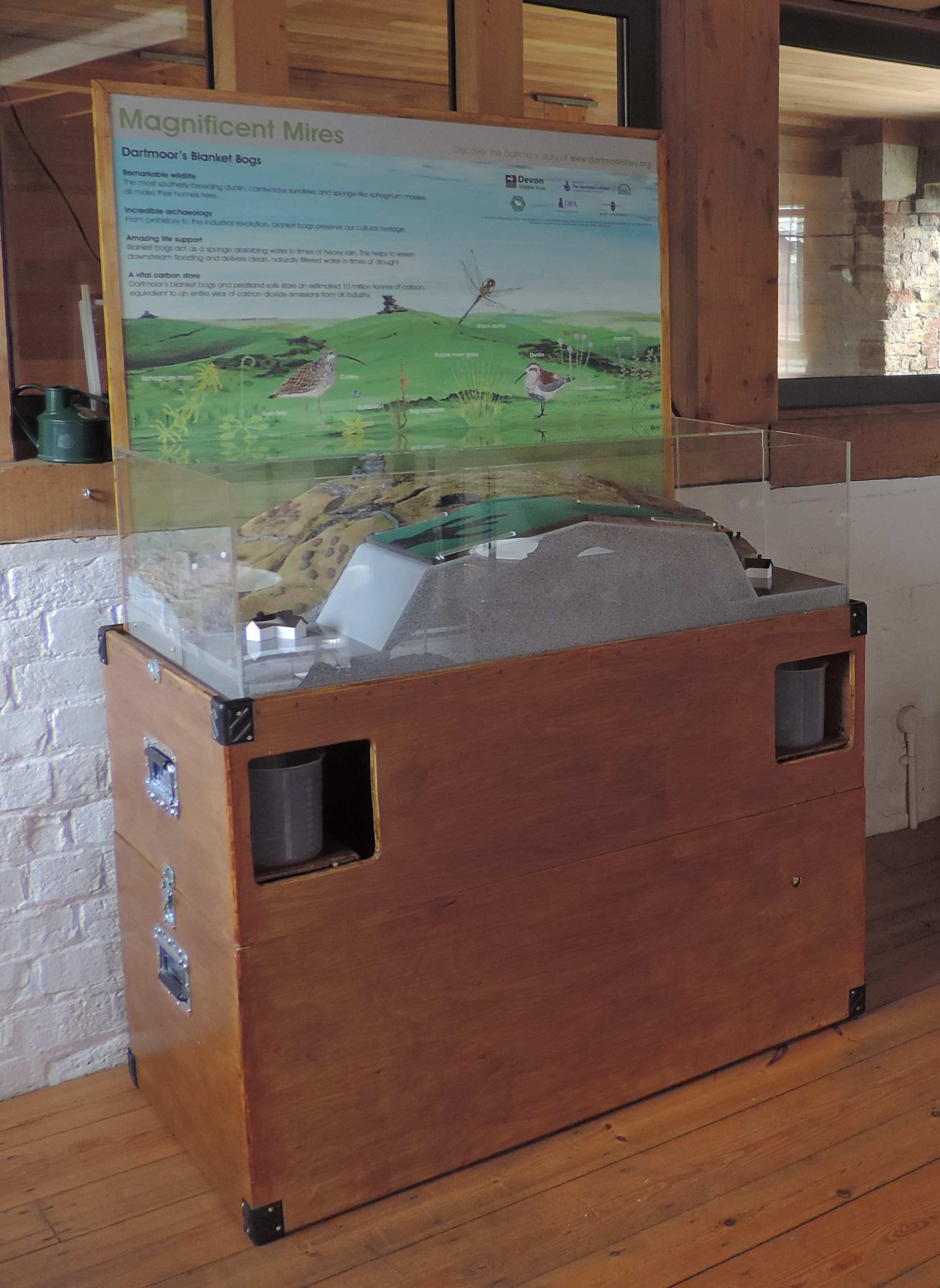
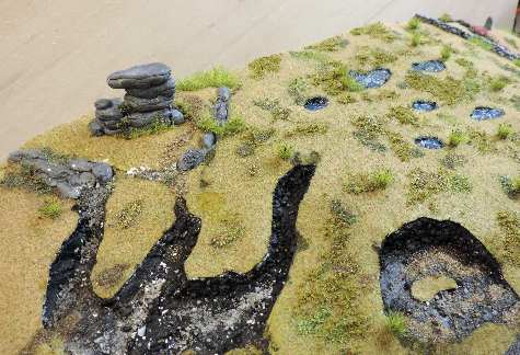
'A Slice of Dartmoor' was a special interpretative model commissioned for the Magnificent Mires project. The front part allows live demonstrations to show how a healthy bog soaks up rain and storm-water to help protect lower lying land from floods. Behind this, a realistic landscaped model captures some of Dartmoor's iconic features like tors and upland pools and puts the diversity of its bogs into context. It also shows the damage that erosion can cause to precious peatland habitat. The unit is completed by a large panel featuring colourful Dartmoor species.
Some of the challenges met during the commission included:
- Finding a suitable material to simulate peat in its absorbency, texture and appearance.
- Simulating the thin layer of vegetation on a bog that helps trap rainwater.
- Making the large display model portable.
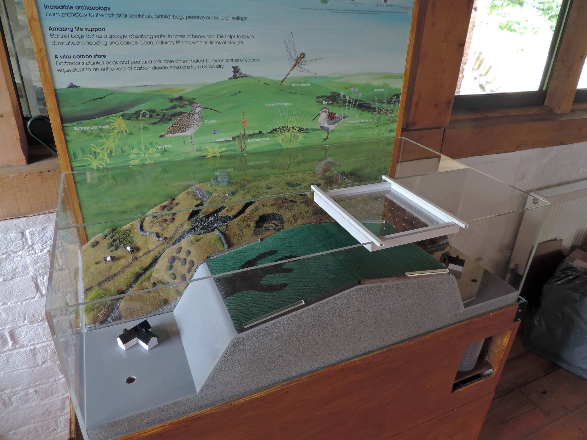
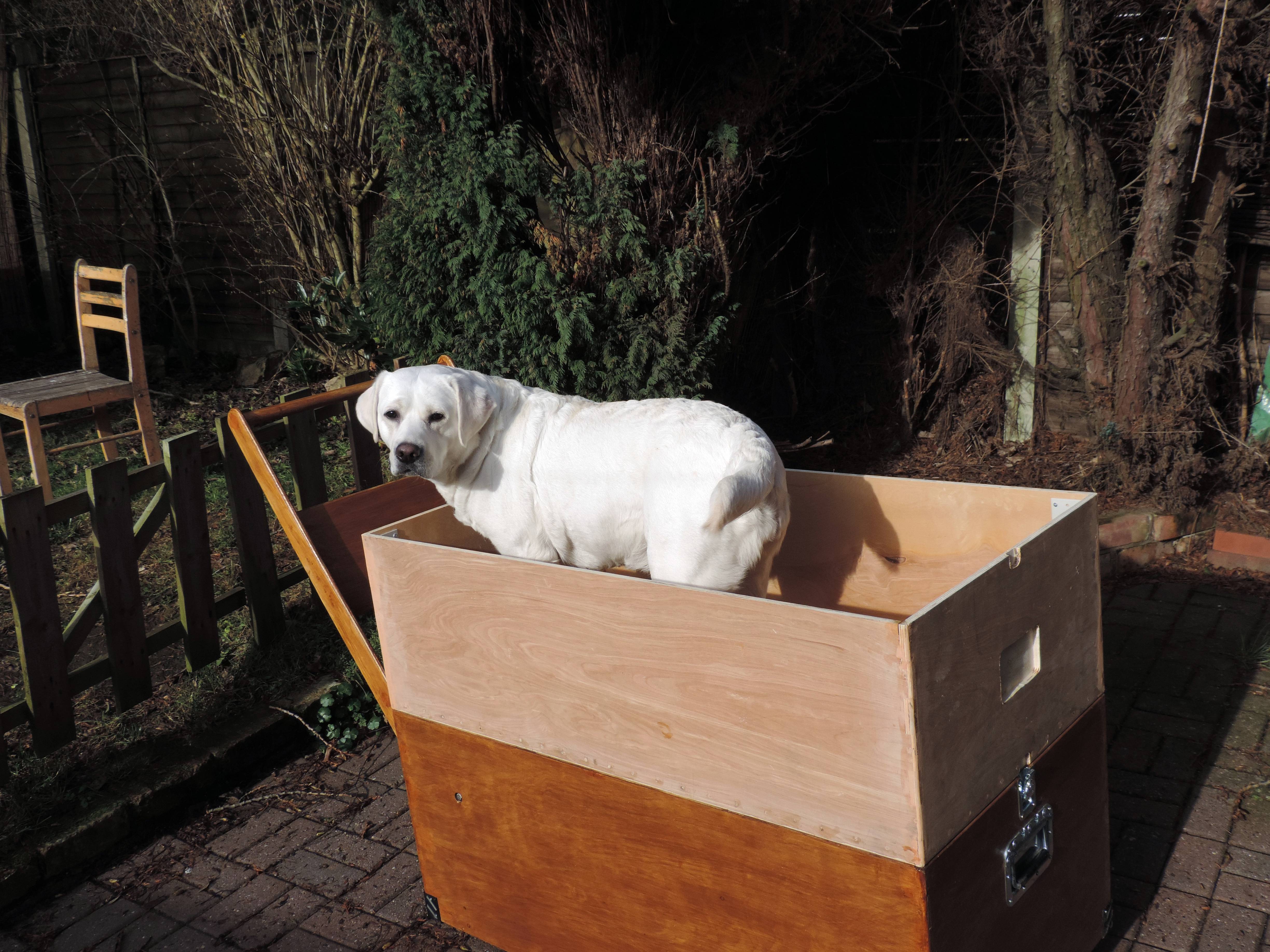
Our final solution was to make the base of the unit also serve as safe storage for the model and to have retracting wheels and a fold-out handle for easier transport. Here's NWE's official Eco-Labrador, Luna, testing out the portability of the base unit: